The Peak District is the cradle of British outdoor activism: the 1932 Kinder Scout mass trespass forced the right-to-roam legislation that opened the rest of the country's uplands, and the National Park itself (established 1951) was the first in Britain. Today it's the second most-visited national park on Earth after Mount Fuji — thirteen million people live within an hour's drive, the Pennine Way starts at Edale, and Stanage Edge is the most-climbed gritstone crag on the planet. This is your complete guide to hiking in the Peak District: routes, character, transport, kit, and what the White Peak / Dark Peak split actually means for what you'll walk on.
At a glance
| Routes in this guide | 1 long-distance trail (Pennine Way Hike) + the major Peak day-walks |
| Distance range | 4 miles (Mam Tor loop) to 268 miles (Pennine Way) |
| Difficulty range | Easy (Hope Valley village walks) to Grade 1 scramble (Kinder Downfall) |
| Best season | April to October; gritstone classics also brilliant on cold winter days |
| Base towns | Hathersage, Castleton, Edale, Bakewell, Hayfield, Buxton |
| Train access | Hope Valley line (Manchester — Sheffield) covers the central Peak |
| Two halves | White Peak (limestone, south) vs Dark Peak (gritstone, north) |
Why hiking in the Peak District is different
The Peak District is two distinct landscapes welded together by a single National Park boundary, and which half you walk in matters more than people realise. The White Peak is limestone country in the south — the dales (Dovedale, Lathkill Dale, Wolfscote, Beresford), the stone-walled fields, the honey-coloured villages (Bakewell, Hartington, Eyam, Tideswell). Easier walking, gentler climbs, more pubs. The Dark Peak is gritstone country in the north — Kinder Scout, Bleaklow, Howden Moors, the Stanage and Curbar edges, peat bog above 500m, sterner weather, the high serious moorland. Different rock, different geology, different vegetation, different walking experience.
The Hope Valley sits between the two and is the standard hiking base for both. Mam Tor's ridge marks the boundary on a single skyline — limestone Hope Valley to the south, gritstone Edale Valley to the north.
What also makes the Peak District different from any other British hill range: access. The park is shared by 13 counties' worth of cities — Sheffield 30 minutes east, Manchester 30 minutes west, Derby 45 minutes south, Leeds an hour north. The Hope Valley railway line cuts straight through the centre — trains every 30 minutes, walks from village stations. No other UK mountain area has anything like this rail density. Sheffield-based walkers do Stanage Edge as a pre-work evening walk and Kinder Scout as a Saturday morning.
What it isn't is genuinely high. The highest summit (Kinder Scout) is 636m, well below Snowdon, Scafell or any Munro. But peak elevation is the wrong metric. Kinder's featureless peat plateau is the most-rescued summit in England — lower than the Lakes, more dangerous in mist than people expect, with bog underfoot and a path network that genuinely confuses people. Underestimating the Peak District is the standard mistake.
The routes worth knowing
| Route | Distance | Ascent | Days | Character |
| The Pennine Way Hike | 268 miles | ~11,000m total | 15-20 | Starts at Edale; first 25 miles are Peak District |
| Mam Tor ridge loop | 4 miles | 300m | 1 | The standard Peak District first walk |
| Kinder Scout circuit (Edale) | 8 miles | 550m | 1 | England's most-hiked plateau; navigation matters in mist |
| Stanage Edge full traverse | 10 miles | 300m | 1 | Skyline gritstone edge, top of the world feel |
| Dovedale to Milldale | 6 miles | 150m | 1 | White Peak limestone; family classic via stepping stones |
| Hope Valley round (Win Hill + Lose Hill + Mam Tor) | 14 miles | 750m | 1 | The big Peak District ridge day |
| Bleaklow from Snake Pass | 8 miles | 400m | 1 | The proper Dark Peak experience — bleak in summer, brutal in winter |
Of these, the Mam Tor ridge loop is the standard starter — 4 miles, 300m ascent, ridge views both sides, accessible from Castleton bus or the Mam Tor National Trust car park. The Stanage Edge traverse is the standard gritstone introduction — an easy walking day on top of the country's most famous climbing crag. The Pennine Way's first day from Edale to Crowden via Kinder Scout is the standard test of whether you're ready to walk the full route — if you find that day hard, the next 250 miles will be harder.
How to choose the right Peak District hike for you
First Peak walk? Start with Mam Tor.
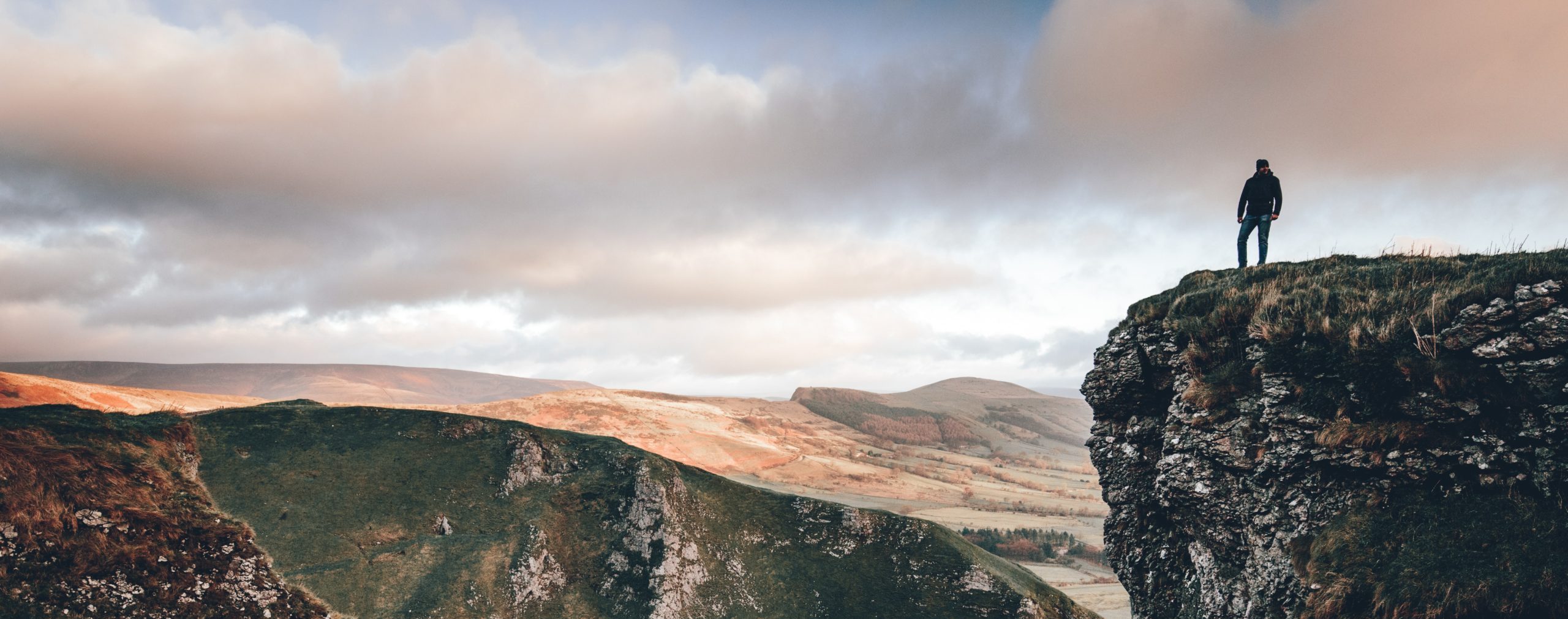
Mam Tor — the "Shivering Mountain" above Castleton — is the most-walked summit in the Peak District. A 4-mile loop from the Mam Tor National Trust car park covers the ridge from Mam Tor to Lose Hill via Hollins Cross and Back Tor, with views of both the Hope Valley (south) and the Edale Valley (north). It's the standard introduction to Peak District ridge walking.
Want gentler? White Peak dales.
Dovedale to Milldale (6 miles, almost no ascent) is the family classic — stepping stones across the River Dove, limestone pinnacles, the Tissington Trail nearby. Lathkill Dale and Beresford Dale are quieter alternatives.
Comfortable hill walker? The Hope Valley round.
Win Hill + Lose Hill + Mam Tor as a single 14-mile day — 750m of ascent, ridge-skyline walking the whole way, finishing in Castleton for the pub. The hardest legitimate Peak District day-walk that doesn't require navigation skill.
Want to navigate? Kinder Scout.
The Kinder circuit from Edale (8 miles, 550m) is the test piece. In summer with clear visibility it's a fine ridge walk on the southern edge of the plateau, returning across Kinder Downfall. In any weather where the plateau is in cloud, you'll need a map, compass and the confidence to use them — the plateau is genuinely featureless and the path network confuses people. Mountain Rescue gets called here more often than to any other Peak summit.
Multi-day backpacker? The first three days of the Pennine Way.
Edale to Crowden (16 miles) to Standedge (12 miles) to Mankinholes (14 miles) is the Peak District section of the Pennine Way. It's the hardest opening to any UK National Trail — Kinder Scout, Bleaklow and the Black Hill in three consecutive days — and if you handle it you can handle the rest of the route.
When to go: Peak District hiking by season
April to October is the standard hill-walking window. April is the late-spring photographer's favourite (lambing, bluebells, dry stone walls in clear light). May and June have the longest daylight and the most settled weather, especially the eastern White Peak which sits in a partial rain shadow. September and October bring autumn colour through the dales and the Bakewell-Buxton woodlands. November to March is more interesting than people think — the gritstone edges (Stanage, Curbar, Froggatt) are at their best on cold dry winter days when the friction is good and the rock is clean, and the lower paths drain better in February than in October.
The Kinder Scout / Bleaklow plateau in winter is a different animal — peat bog freezes to glass, the path disappears under snow, navigation becomes serious. Treat it as winter mountain country from mid-December to mid-February in most years. The dales (Dovedale, Lathkill, Beresford) remain walkable year-round.
Mid-August Bank Holiday is the worst weekend for Peak District crowding — Edale, Castleton and Hathersage car parks fill from 8am, the popular paths (Mam Tor, Kinder via Jacob's Ladder) have continuous foot traffic, parking enforcement is aggressive. Go midweek or off-season; off-peak the Peak District is genuinely uncrowded.
Getting to the Peak District without a car
The Hope Valley line (East Midlands Railway, Sheffield to Manchester via Edale, Hope, Hathersage, Bamford, Grindleford) is the best UK national park rail access by a clear margin — trains every 30 minutes, walks starting from station platforms, day-trip-friendly fares from both city ends. Edale station is five minutes' walk from the Nag's Head pub at the Pennine Way trailhead. Hathersage is the natural climbing-and-walking base on the eastern Peak; Hope is the Castleton + Mam Tor base; Grindleford is on the Stanage Edge approach.
Beyond the Hope Valley line, Buxton is reached from Manchester (Northern, ~50 min). Bakewell has no train (the line closed in 1968) but is well-served by buses from Sheffield, Chesterfield and Matlock. The Manchester Piccadilly — Glossop service serves the western Dark Peak. The High Peak Buses 257 and 273 cover Castleton — Edale — Hayfield, useful for one-way walks.
Where to base yourself
Hathersage is the Sheffield-side base — Stanage Edge a 30-minute walk away, the Outside outdoor shop in the village, the Scotsman's Pack and the Plough as the established walker pubs. Castleton is the central Peak base — the show caves, Mam Tor at the doorstep, Peveril Castle, multiple pubs. Edale is the Pennine Way base and the closest to Kinder Scout — smaller, quieter, the Nag's Head and the Old Nags Head as the walker pubs. Bakewell in the White Peak is the southern alternative — market town centre, the dales within 20 minutes' drive. Hayfield is the Manchester-side base — closest to Kinder's western approach via Kinder Reservoir and William Clough. Buxton is the spa-town base — the Buxton Country Park, the Goyt Valley, less Peak-typical but quieter.
Kit specific to the Peak District
Peak District kit is more forgiving than the Lake District or Snowdonia kit because most of the popular routes are sub-700m and walkable in trail shoes in summer. Waterproof boots become non-negotiable for any walk above the edges — Kinder's peat in particular sucks water uphill. A 1:25,000 OS map (Explorer OL1 covers the Dark Peak, OL24 the White Peak) is essential for Kinder Scout and Bleaklow — the path network is dense and the visibility unreliable. The Mountain Weather Information Service publishes a dedicated Peak District forecast at mwis.org.uk. For the gritstone edges (Stanage, Curbar, Froggatt), pack a thermos — the views invite a long stop. The BMC's Regional Access Database flags any seasonal nesting-bird closures on the climbing edges, which can affect adjacent walking access.
Common questions about hiking in the Peak District
What is the most popular hike in the Peak District?
Mam Tor — the "Shivering Mountain" above Castleton — is the most-walked summit in the Peak District. A 4-mile loop from the Mam Tor National Trust car park covers the ridge from Mam Tor to Lose Hill via Hollins Cross and Back Tor, with views of both the Hope Valley (south) and the Edale Valley (north). It's the standard introduction to Peak District ridge walking.
Where does the Pennine Way start?
The Pennine Way starts at the Nag's Head pub in Edale, in the Peak District. From there it climbs Jacob's Ladder onto the Kinder Scout plateau within the first three hours, then runs 268 miles north to Kirk Yetholm on the Scottish border. Edale station (Hope Valley line from Sheffield/Manchester) is five minutes' walk from the trailhead.
What's the difference between the White Peak and the Dark Peak?
The White Peak is the limestone country of the southern Peak District — the dales (Dove, Lathkill, Wolfscote), the villages (Bakewell, Hartington), gentler walking, paler rock. The Dark Peak is the gritstone moorland of the northern Peak — Kinder Scout, Bleaklow, Stanage, peat bog underfoot, sterner weather, the seriously high country. The Hope Valley sits between them and is the standard base for both.
Is Kinder Scout dangerous?
Kinder Scout in summer is a featureless peat plateau with notoriously poor navigation in mist — straightforward in clear conditions, surprisingly serious in cloud. Most days are fine; one day in five (autumn through spring) you need a map, a compass and the confidence to use them. Mountain Rescue is called to Kinder more than any other Peak District summit.
Can I hike on Stanage Edge?
Yes — Stanage Edge has a clear footpath running along its 4-mile gritstone crest above Hathersage. It's easy walking with non-stop views, doubles as the country's most famous climbing crag (200+ routes), and connects via Burbage and Carl Wark to make a 10-mile day. Park at Hollin Bank or take the train to Hathersage and walk up.
What else is in this region
The Peak District is small enough to combine activities in a single weekend. Peak District rock climbing covers Stanage, Burbage, Froggatt and Curbar — gritstone is best done in person, and the Peak District is its global capital. Cannock Chase mountain biking sits an hour south for the trail-centre option; Sherwood Pines is the East Midlands variant. Peak Airsports paragliding flies the Mam Tor ridge — one of the best ridge-soaring sites in England. For broader regional context see Northern England. Or step sideways to Hiking in the Lake District for English mountain country or Hiking in Scotland for the genuine high stuff.
Related guides
Planning the practicalities? See the best time of year to walk each National Trail, how to walk them car-free, and where you can legally wild camp in the UK.
Where to hike
in the Peak District.
Plan it yourself.
The most authoritative sources we know of for this route — routes, conditions, governing bodies and operators. Open in a new tab.
- National Trails official body for the 15 long-distance National Trails of England and Wales.
- OS Maps Ordnance Survey for paper sheets and the OS Maps app for route planning.
- Mountain Weather Information Service free upland weather forecasts — the standard reference for British hill walkers.
- Long Distance Walkers Association route database covering hundreds of UK long-distance trails beyond the National Trails network.