Hiking in Scotland is in a different category from anywhere else in the UK. 282 Munros (peaks above 3,000 feet), 222 Corbetts, 219 Grahams, the highest mountain in Britain (Ben Nevis, 1,345m), the most committing summer ridge (the Cuillin on Skye), the only consistent UK winter mountaineering season, the only legal Right to Roam, the Caledonian Sleeper that drops you off three hours from a Munro summit. England has hills. Scotland has mountains. This is your complete guide to hiking in Scotland: routes, Munro-bagging culture, weather, the rail-foot combinations, and what hiking here actually looks like across the seasons.
At a glance
| Routes in this guide | West Highland Way + the country's major hiking regions |
| Distance range | 4 miles (Goatfell summit, Arran) to 470 miles (Cape Wrath Trail) |
| Difficulty range | Easy (lochside walks) to expert (Cuillin Traverse, winter Nevis) |
| Best season | May, June and September; December-March for winter mountaineering |
| Munros (3,000ft+) | 282 in total; ~95% require nothing technical in summer |
| Highest summit | Ben Nevis, 1,345m |
| Right of access | Land Reform (Scotland) Act 2003 — UK's only general right to roam |
| Train highlights | Caledonian Sleeper from London Euston direct to Fort William; West Highland Line |
Why hiking in Scotland is different
Three things separate Scotland from England and Wales for hill walking. The scale: Scotland holds roughly 80% of the UK's land above 700m. The Cairngorms National Park alone is larger than Luxembourg. The Highlands' road network is thin enough that route planning starts with road access, not summits — whole valleys (Glen Affric, Knoydart, Strathfarrar) feel genuinely remote. The right to roam: the Land Reform (Scotland) Act 2003 grants a general right of responsible access to most unenclosed land in Scotland, including the right to wild-camp on the same. This is genuinely unique in the UK — England, Wales and Northern Ireland have no equivalent right. The winter season: Scotland is the only UK country with reliable winter mountaineering conditions. December to March, the Cairngorms, Glen Coe, Ben Nevis north face and the Cuillin are the equal of any equivalent-altitude European range for winter alpinism.
The cultural piece is Munro-bagging. Sir Hugh Munro published his "Tables" in 1891 listing the 283 separate peaks above 3,000 feet (the number's revised slightly over time; currently 282). The cultural sport of climbing all of them — "doing the Munros" — takes most committed walkers 8-12 years. The first person to complete the round was the Reverend A.E. Robertson in 1901. Approximately 7,000 people have completed it as of 2024 — a number that's roughly doubled in the last decade. Scottish Mountaineering Club keeps the official register.
Practical access matters here more than in any other UK range. The Caledonian Sleeper from London Euston (nightly except Saturdays) drops walkers in Fort William before breakfast, three hours from Ben Nevis's summit by foot. ScotRail's West Highland Line from Glasgow Queen Street to Fort William and Mallaig is one of the world's great rail journeys and one of the practical pieces of the puzzle — Bridge of Orchy, Tyndrum and Crianlarich are walk-on-walk-off Munro stops. CalMac ferries handle the islands; book vehicle deck space well in advance May to September.
The major hiking regions of Scotland
Scotland's hiking country breaks into seven roughly distinguishable regions, with character changing significantly between them.
| Region | Character | Headline routes / summits |
| West Highlands | The classic Scottish mountains; concentrated alpine character | Ben Nevis, Glen Coe, Knoydart |
| Cairngorms | Largest National Park; sub-arctic plateau; winter sports centre | Ben Macdui, the Lairig Ghru, Cairngorm summit |
| Northern Highlands | Remote, less-walked; sandstone peaks; the empty quarter | Suilven, Stac Pollaidh, Quinag, the Five Sisters of Kintail |
| Skye and the Inner Hebrides | The most committing UK ridge (Cuillin); sea-cliff scrambling | Cuillin Ridge, Sgurr nan Gillean, the Storr |
| Outer Hebrides | Atlantic-edge wilderness; gentle hills; beach walking | An Cliseam (Lewis), Beinn Mhor (South Uist) |
| Trossachs and Loch Lomond | Easiest day-trip from Glasgow; first Munros for many | Ben Lomond, Ben A'an |
| Southern Uplands / Borders | Gentler hills; the southern third of mainland Scotland | Tinto Hill, the Cheviots, Merrick |
Of the long-distance trails, the standout is The West Highland Way (96 miles, Milngavie to Fort William, 7-9 days). The Great Glen Way (78 miles, Fort William to Inverness) is the second-most-walked. Scotland's Great Trails network adds about 30 longer-distance routes — the Speyside Way, the Southern Upland Way (212 miles coast-to-coast), the Cape Wrath Trail (470 miles, unmarked, expedition-style), the Skye Trail (78 miles, technical).
How to choose the right Scotland hike for you
First serious mountain walk in Scotland? Ben Lomond.
Ben Lomond from Rowardennan (974m, 7 miles round, 970m ascent) is the standard introduction. Train to Balloch then ferry across Loch Lomond to Rowardennan; alternatively drive to Rowardennan car park. It's the southernmost Munro and arguably the easiest to navigate. A clear summer day with good visibility gives one of the great views in Scotland — the Trossachs north, the Lowlands south, Arran west.
Done a few hills? Ben Nevis via the Mountain Path or the Cairngorm tops.
Ben Nevis via the standard Mountain Path / Pony Track is 10 miles round, 1,350m ascent, the highest summit in Britain. It's relentless rather than technical; the path is well-graded but unrelenting. Avoid in winter without ice axe and crampons (regular fatalities). Alternative: the Cairngorm-Ben Macdui ridge from Coire Cas car park (12 miles, 700m ascent net but high starting point) covers two Munros on the sub-arctic plateau with relatively gentle gradients.
Multi-day? The West Highland Way.
The West Highland Way (96 miles, 7-9 days, Milngavie to Fort William) is the most-walked Scottish long-distance route and the natural multi-day introduction. The terrain is genuinely varied — Loch Lomond's wooded eastern shore, the Rannoch Moor crossing, the Devil's Staircase, Glen Coe's western edge, the final descent into Fort William. Book accommodation 6 months ahead for May-September; wild camping is legal but regulated within the Loch Lomond bylaw zone.
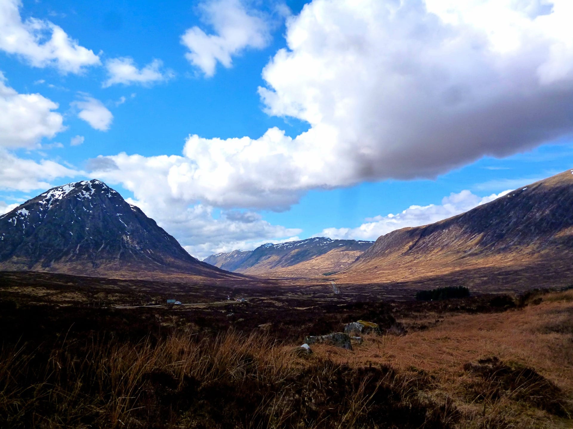
Want serious mountain terrain? Glen Coe day routes.
Glen Coe holds the most concentrated mountain hiking in Britain. The Buachaille Etive Mòr at the head of the glen (Stob Dearg summit, Munro, route via Coire na Tulaich) is one of the iconic mountain days. The Aonach Eagach ridge on the north side of the glen is a Grade 2 scramble, not hiking. The Bidean nam Bian massif on the south side gives multiple Munro options with multiple route choices. Walking these in summer requires confidence with steep ground and route-finding.
The Cuillin?
The Cuillin Ridge on Skye is not a hike. It's a Grade 3 scramble with mandatory rock-climbing sections and the most committing day's mountaineering in the UK. Treat it as a separate sport.
When to go: Scotland hiking by season
May and June are unequivocally the optimum months. Long daylight (16-20+ hours; pure light at midnight in Shetland), settled spells between weather systems, pre-midge in most of the Highlands, snow gone from most non-Cairngorm Munros. Mid-May is the photographers' favourite. July and August are warm and busy — midges everywhere on the west coast and inland glens (a head net is genuinely required), tourist traffic on Skye and Glen Coe peaks; conditions can be wet. September is the post-midge quiet repeat of June — arguably the best single month for Munro-bagging.
October brings autumn colour and the rutting deer — spectacular in the Cairngorms and Glen Affric. Daylight shortens fast. November is the wettest single month statistically. December to March is genuine winter mountaineering season — the only consistent alpine-style season in the UK. The Scottish Avalanche Information Service publishes daily forecasts for six main ranges (Northern Cairngorms, Southern Cairngorms, Glen Coe, Lochaber, Creag Meagaidh, Torridon) from December to April; sais.gov.uk is the standard daily reference. April is the wildcard — snow on tops, cold rain at sea level, sometimes the best month of the year for the well-timed snow-condition Munro day.
Two specifics worth knowing: midges (May to early September on the west coast) are real, abundant, and require Smidge or DEET 50%+ to manage. Avoid still windless evenings in glens or near standing water. And ticks — carrying Lyme disease at meaningful rates in the western Highlands — require check-and-remove protocol after every walk through bracken or long grass.
Getting to Scotland without a car
The rail-foot combinations are the most romantic in the UK and they're genuinely practical. The Caledonian Sleeper from London Euston runs nightly to Edinburgh, Glasgow, Inverness, Aviemore and Fort William — the most efficient way into the Highlands. Step off at Fort William at 8:30am and you can be at Ben Nevis's summit by 1pm. The West Highland Line (Glasgow Queen Street to Fort William and Mallaig) is one of the world's great rail journeys — the section from Crianlarich to Rannoch crosses Rannoch Moor on raft foundations and is straight-up dramatic. ScotRail covers the Borders, central belt, Cairngorms (Aviemore) and the north (Inverness, Kyle of Lochalsh, Thurso, Wick). CalMac ferries (calmac.co.uk) handle the islands; book vehicle deck May to September. Citylink coaches cover the route network where rail doesn't reach — particularly useful for Skye, the Outer Hebrides via Uig, and the north-west.
Where to base yourself
Fort William is the obvious mountain base — Ben Nevis, Glen Nevis, the end of the West Highland Way, Caledonian Sleeper from London, West Highland Line. Aviemore is the Cairngorms hub — ski-mountaineering centre, the Speyside Way, the highest summit (Ben Macdui) 7 miles from the high car park. Glencoe Village is the climbing centre — Clachaig Inn, Glen Coe Mountain Resort, walking-distance to the iconic glen's footpaths. Inverness is the northern Highlands gateway — trains south to London, road to the north coast, ferry routes east. Portree is the Skye base — ferries, the Cuillin, the Old Man of Storr. Ullapool is the north-west base — Suilven, Stac Pollaidh, the ferry to Stornoway. For Lowlands hiking, Edinburgh is the natural base (Pentlands at the doorstep, Borders an hour south, Cairngorms 2h30 north).
Kit specific to Scottish hiking
Scottish hill kit is the most demanding of any UK range. Year-round summer kit: waterproof boots (not shoes), full waterproof shell with hood, waterproof overtrousers, a real thermal mid-layer, hat and gloves even in summer (the tops can be 5°C colder than the glen), a map (Harvey's Scotland series or 1:25,000 OS Explorer sheets), a compass, a head torch (daylight margin matters — rescues happen at dusk). Add for winter (Dec-Mar): ice axe, B2-compatible crampons, climbing helmet (rockfall and ice debris), a winter-rated sleeping bag for any overnight, avalanche-awareness training if you intend to walk in steep terrain. The non-obvious additions: Smidge or 50% DEET (midges, May-September), a Lyme tick remover (the Highlands have the highest UK Lyme rates), a personal locator beacon or Garmin inReach for anything genuinely remote (the Highlands have the country's largest single area with no mobile signal). Mountain Weather Information Service publishes dedicated forecasts at mwis.org.uk for the West Highlands, the Cairngorms, the Northern Highlands and the Southern Highlands; check before every walk above 600m.
Common questions about hiking in Scotland
What's the most popular long-distance walk in Scotland?
The West Highland Way is by a clear margin Scotland's most-walked long-distance route — 96 miles from Milngavie on the edge of Glasgow to Fort William at the foot of Ben Nevis, opened 1980 and walked by 30,000+ people a year. The Caledonian Sleeper from London Euston direct to Fort William makes the rail-foot combination one of the world's great walking adventures.
How many Munros are there in Scotland?
There are 282 Munros — Scottish peaks above 3,000 feet (914m). "Munro-bagging" is the cultural sport of climbing all of them, typically over years; the average completion takes 8-12 years. The first to complete the round was the Reverend A.E. Robertson in 1901. Approximately 7,000 people have completed the round as of 2024.
What's the right to roam in Scotland?
Scotland's Land Reform Act 2003 grants a general right of responsible access to most unenclosed land in Scotland, including the right to wild-camp on the same. This is genuinely unique in the UK — England, Wales and Northern Ireland have no equivalent right. The Loch Lomond and Trossachs bylaws are the main exception, requiring permits for camping at lochside sites between March and October.
When can I do winter mountaineering in Scotland?
Reliable Scottish winter conditions run from late December to mid-March, with the best ice routes typically forming in late January and February. The Scottish Avalanche Information Service publishes daily forecasts for the six main ranges (Northern Cairngorms, Southern Cairngorms, Glen Coe, Lochaber, Creag Meagaidh, Torridon) from December to April. The Scottish winter is the UK's only consistent alpine-style season.
Do I need to book accommodation on the West Highland Way?
Yes, in advance, especially May through September. The Way passes through several villages with limited bed space (Bridge of Orchy, Kingshouse, Glencoe village) where the entire local accommodation can be booked out 6 months ahead. Wild camping is legal and a popular fallback; the Way is regulated against camping in the Loch Lomond bylaw zone (Drymen to Rowardennan) March-October.
What else is in this region
Scotland rewards multi-activity weeks. Glen Coe rock climbing covers the Buachaille and the great mountain crags — the country's most atmospheric trad climbing. Fort William mountain biking at Nevis Range is the UK's only UCI World Cup downhill venue. Glentress and the 7Stanes in the Borders is one of Europe's largest MTB networks. Cloudbusters paragliding flies Tinto Hill in the Lowlands. Foxlake wakeboarding sits half an hour east of Edinburgh. For broader views see the Scottish Highlands & Islands region page or the Scottish Lowlands & Borders region page. Or step back to Hiking in the Lake District for English mountain country at smaller scale, or Hiking in Snowdonia for the Welsh equivalent.
Related guides
Planning the practicalities? See the best time of year to walk each National Trail, how to walk them car-free, and where you can legally wild camp in the UK.
More Scottish adventures
Beyond the hills, Scotland fills the map with kayaking on Loch Lomond, paddleboarding on Loch Morlich, wild swimming at the Fairy Pools, scuba diving in Scapa Flow, wild camping in Glen Coe, a wild camp at Sandwood Bay, Ben Nevis, the Cuillin and Buachaille Etive Mòr — each with its own page, directions and access notes.
Where to hike
in Scotland.
Plan it yourself.
The most authoritative sources we know of for this route — routes, conditions, governing bodies and operators. Open in a new tab.
- National Trails official body for the 15 long-distance National Trails of England and Wales.
- OS Maps Ordnance Survey for paper sheets and the OS Maps app for route planning.
- Mountain Weather Information Service free upland weather forecasts — the standard reference for British hill walkers.
- Long Distance Walkers Association route database covering hundreds of UK long-distance trails beyond the National Trails network.